2014

An Antenna on Napatree? What is this neighborhood coming to?
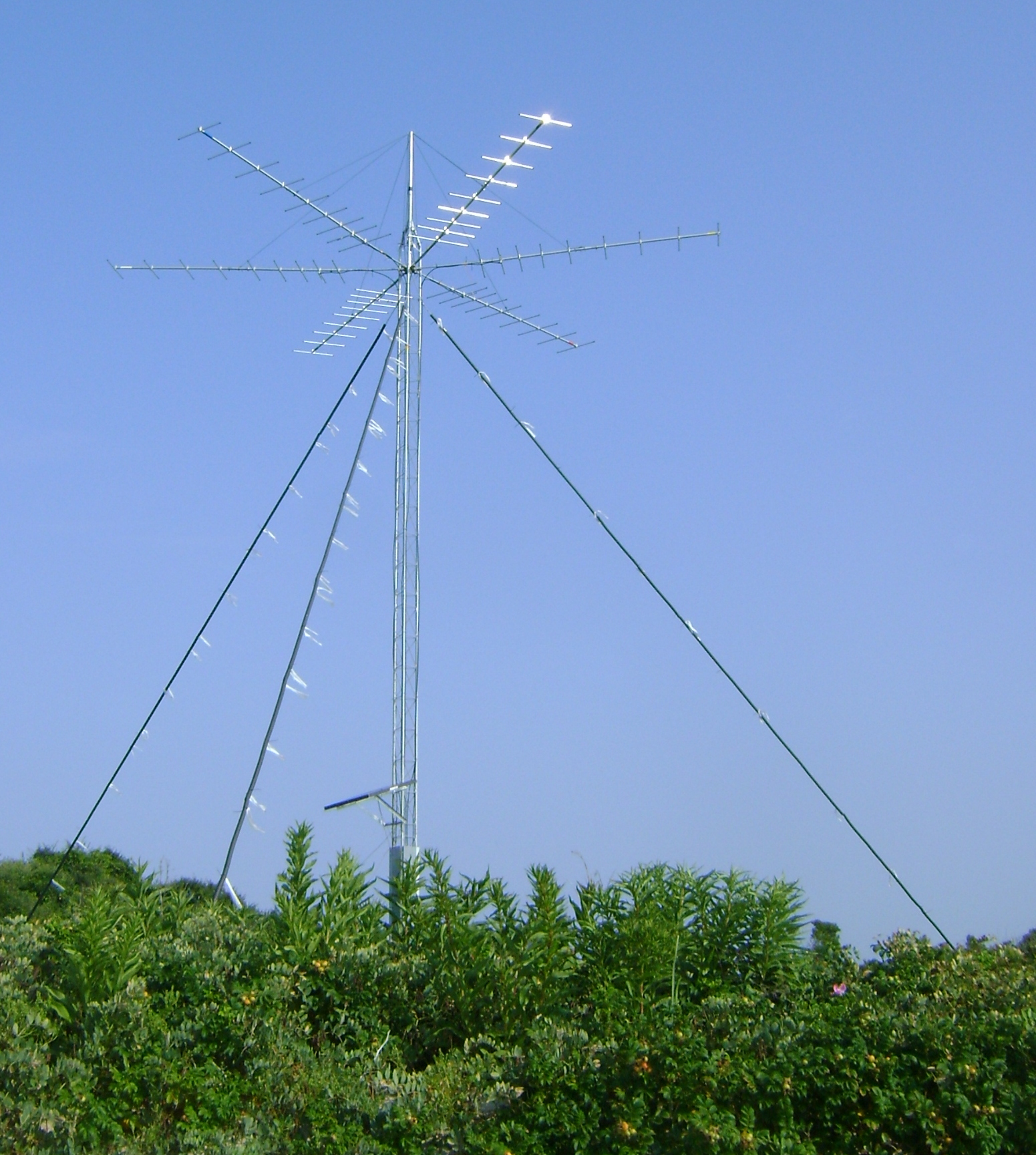
Napatree Point’s antenna
Note: “Science and Nature for a Pie” is now on Facebook! Visit www.facebook.com/scienceandnatureforapie and “like” the page for ongoing discussions, photos, and factoids!
Taylor Swift’s cell phone tower? Some new spying gadgetry from the NSA? Wrong on both counts. Then why on earth is a 40-foot tall antenna rising from the dunes at Napatree Point Conservation Area in Westerly, RI? Fear not. This is an instrument being used by doctoral candidate Pam Loring of UMass Amherst to monitor the movement of common terns.
A sign posted in front of the tower reads: “This temporary radio tower is part of a research project conducted by the University of Massachusetts – Amherst and the U.S. Fish and Wildlife Service. Its six directional antennas are collecting around-the-clock data on the offshore movements of migratory birds and bats carrying lightweight radio transmitters. Similar radio tracking stations are deployed throughout the Northeast as part of a broader Atlantic Flyway Network.”

Common Tern (Sterna hirundo) in flight near Lake Ontario. Photo: gschneiderphoto.com .
Today, Pam Loring is travelling in an all-terrain vehicle (ATV) along the shore of Napatree for her first data download in 19 days. Loring is doing research on the movement patterns of common terns (Sterna hirundo), and this is one of 11 stations she has set up at locations ranging from Napatree to Great Gull Island (between Block Island and Long Island Sounds) to Cape Cod. Two are even receiving information while mounted on boats.
This summer, Loring tagged 51 birds on Great Gull Island and 70 on Monomoy National Wildlife Refuge in Chatham. Since determining the sex of the birds is nearly impossible in the field, sample feathers from each bird had to be sent to a lab in Florida for molecular analysis before the determination could be made. Then a tiny transmitter known as a nanotag is affixed to its back. The nanotag antenna resembles a guitar string, and the entire tag weighs a gram, so it does not affect the bird or its flight. The tags on Loring’s birds send out a signal every five seconds. Her antennas will pick up those pulses, thereby determining the location and movement patterns of the birds that fly within range. The data is recorded in a device that sits inside a trunk-like hard plastic container. It’s this device that is the object of her quest today.

A nanotag similar to those used by Pam Loring. Photo: lotek.com
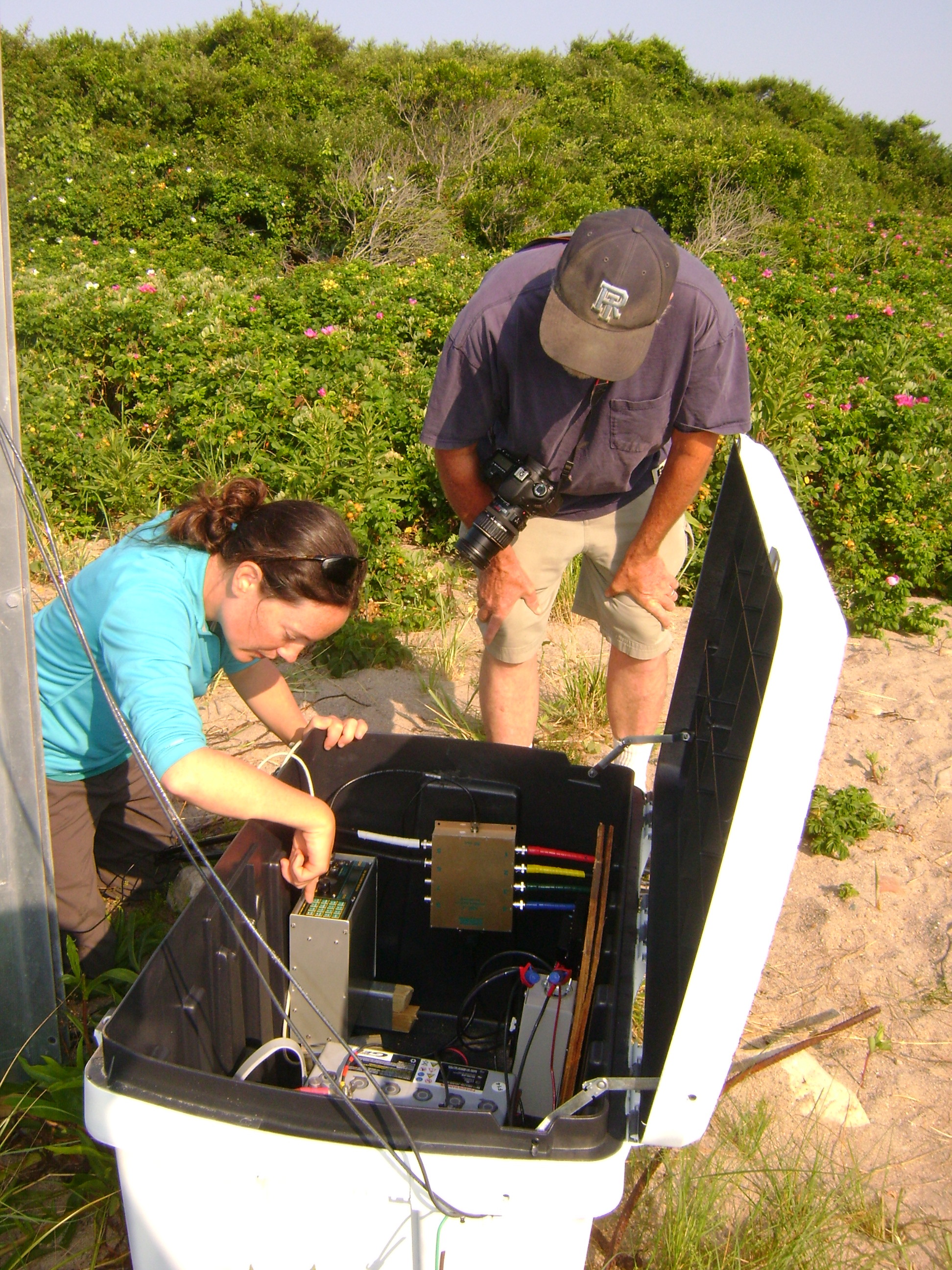
Loring unlocks the padlock on the container and lifts the lid. Accompanying her on this trip is Dr. Peter Paton, Professor and Chair of the University of Rhode Island’s Department of Natural Resources Science.
URI Prof. Peter Paton observes Loring as she runs through her equipment check.
He gives a small cheer when the box is opened and the two see the flashing LED lights on the equipment that indicates that there is indeed data being recorded. (Equipment failure is rare, but heartbreaking.)

Doctoral candidate Pam Loring uploads data from the tracking station.
Loring pulls a laptop from a waterproof bag and proceeds to download the data. She grits her teeth a bit as she deletes the data from the system: until she returns home and uploads it to other drives, her laptop will be the only record of the vital information she is collecting.

Checking the connections.
Data collected, equipment and passengers pile into the ATV for the return trip to the parking lot. While specific data will need to await her decoding, there are some pieces of information she can glean from today’s visit immediately: first, her electrical equipment seems to be functioning properly. Second, signals have been received roughly 35,000 times in the last 19 days. Loring explains that 90% of that will likely turn out to be false readings. However, that still leaves her with 3,500 pieces of data that are usable, and that will be entered into a complex system of programs that will provide her with the information she’s looking for. The Watch Hill Conservancy, which is charged with managing Napatree Point Conservation Area, will also benefit from the data, since the antenna not only records Loring’s terns, it also reports on any nanotagged animal (bird or bat) that passed within the antenna’s range. (The antenna has an average range of roughly 10 km., so animals passing within about six miles of Napatree will register.)
From Napatree, Pam Loring will journey to Cape Cod for the next data collection. In October, all the antennas will be dismantled for the winter, to be reassembled for monitoring from spring to autumn in 2015. “It’s great that we have this antenna here,” she says as she climbs into her truck. “It’s a terrific opportunity for us to collaborate.” And for now, at least, Napatree will remain free from disturbance by the glitterati or the illuminati.
Leave a comment

Recent Posts
- The Myth of the Lion: Cougars are gone and they’re not coming back
- Cell Phone App Helps Battle Cholera: Research shows hope for reducing infection
- Actionable Information: Improving Storm Damage Predictions
- URI Tracks Mako Sharks
- Cardinals to Cuckoos, Urban Birds are Everywhere
About the Author

Categories
- 41 North Magazine
- A Field Guide to Dragonflies and Damselflies of Massachusetts
- apiculture
- ASRI
- Audubon Field Guide to Mushrooms
- Audubon Society of Rhode Island
- bee keeping
- bees
- BioBlitz
- Bird Feeder
- Blue Crab
- Born to be Wild Nature Center
- Caterpillars of Eastern North America
- Central Fall Middle School
- Dam removal
- damselflies
- diamondback terrapin
- Dr. Chi Chen
- dragonflies
- Eastern Apicultural Society
- Franklin Farm
- frog
- Geology
- Giant Leopard Moth
- Ginger Brown
- Kettle Pond
- land trust
- Light pollution
- mites
- Moth Mingle
- Moths
- Mushrooms
- Narragansett Bay Coyote Study
- Narragansett Indian
- National Audubon Society
- National Audubon Society Field Guide to Insects and Spiders
- Natural Science
- Ningret Wildlife Refuge
- Ninigret
- Ocean State Bird Club
- Outdoor writing
- Red Bellied Woodpecker
- Rhode Island DEM
- Rhode Island Sea Grant
- RIDEM
- RINHS
- Rocky Point Park
- Roger Williams Park Zoo
- Saturday Evening Post
- Save the Bay
- Sharks
- snakes
- Steere Hill Land Trust
- The City Dark
- The Nature Conservancy
- The Sibley Field Guide to Birds of Eastern North America
- Trustom Pond National Wildlife Refuge
- turtles
- Uncategorized
- URI
- URI Coastal Institute
- URI Graduate School of Oceanography
- US Fish and Wildlife
- USFW
- wasps
- Westerly
- White Rock Dam
- Wildlife Rehabilitators of Rhode Island
- Wood Pawcatuck Watershed Association
- WPWA
- WRARI
- Writing

| M | T | W | T | F | S | S |
|---|---|---|---|---|---|---|
| 1 | 2 | 3 | 4 | 5 | ||
| 6 | 7 | 8 | 9 | 10 | 11 | 12 |
| 13 | 14 | 15 | 16 | 17 | 18 | 19 |
| 20 | 21 | 22 | 23 | 24 | 25 | 26 |
| 27 | 28 | 29 | 30 | 31 | ||


